
Republic of Botswana, a country in South Africa. Before independence in 1966 - the British Bechuanaland protectorate. Part of the Commonwealth, led by Britain. Botswana has no outlet to the sea. Bordered on the south and east Africa, west and north - with Namibia, in the north-east - with Zimbabwe. Approximately 2/3 of the total length of its borders is on natural boundaries, mainly along the rivers (Chobe, Ramokgvebana, Shashe, Limpopo, Marico, Molopo, Nosob), part of which is dry in the dry season. The country's population - 1.53 million people (1997), Tswana ethnic group predominates. In the capital city of Gaborone live 140 thousand people.
Climate in Boswana
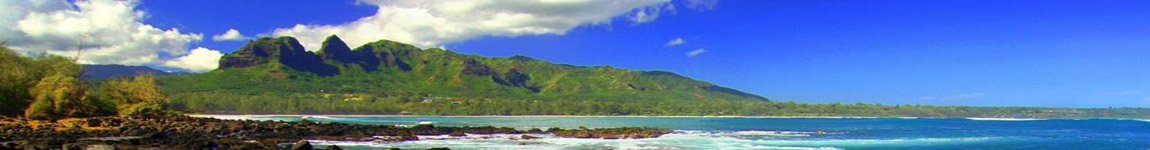
The climate in northern Botswana and tropical Central and South is changing rapidly - from tropical to continental. The average temperature in January in Gaborone is approximately 25 � C and in July it is 16 � C. The average annual temperature is 22 �, while in the southern part of the state is very cold at night, and in the winter time are sometimes even snow, very unusual for this climate zone.Cold and dry season begins at the end of April and lasts until late October. In August and September are particularly frequent sand storms and severe storms. Sand Snow fills pavement, dusty haze found in the air, so even during the day drivers must switch Car headlights to see the road surface. In the period from November to mid-March last season of heavy rains, when the ground is covered with greenery. Most of the precipitation soaks deep into the soil, and this in a little moisture is available only for the roots of certain trees and shrubs. The average annual rainfall in the northern reaches of up to 700 mm Hg and gradually decreases to the south-west. In the Kalahari, this amount does not exceed 230 mm Hg.
Almost 70% of the water consumed in the country is the origin of artesian wells. Kalahari, and the rivers of the country in the off season is completely dry. South-east of the country have drained water from heavily Limpopo River tributaries, but they are greatly reduced for most of the dry years. Very rich in water resources north. It takes Okavango, the deepest river in Botswana and the Chobe River, which is a tributary of the Zambezi River. As for the Kalahari, the term "desert" for it is not quite apply. Judging by the average amount of rainfall, it is more appropriate concept of semi-deserts, savannas, or shrubby areas. In some places, particularly in remote areas grow acacia, baobab, grow, and give the breadfruit and other typical of the flora. In the rainy season there is an abundance of different cacti and plants of the gourd family, which are very helpful and go to feed the animals, which include local farmers.
Wetlands and river basins Okavango Makgadikgadi completely covered with thickets of reed plants, papyrus, elephant grass and shrubbery. Fauna of Botswana has the richness and diversity. There is a common set of large mammals - elephants, giraffes, hippos, zebras, antelopes and many large predators: lion, leopard, cheetah, brown and spotted hyenas and jackals. Very diverse world of birds, including large species such as ostrich, bustard and Chernogrivov bustard. In wet habitats live numerous storks, ducks, herons, flamingos and geese. In the rivers are home to crocodiles. Among a number of venomous snakes are common cobra, mamba and dwarf viper. Among insects in large numbers here live scorpions.
Traditions of Botswana
Komana Kotapa - rite,
known as the "rite of Rain", it is associated with a traditional Bantu
belief in spirits of their ancestors. Bantu people believe that a person
does not die, but only goes to another form of existence. According to
them, the souls of the dead to help the tribe and its people to overcome
various difficulties, but at the same time they may punish the tribe or
its individual members, if the people will not forget them or violate
the rites and customs. It is believed that the spirits of their
ancestors live as long as they are remembered tribesmen.
This ceremony is held in the tribe lobedu twice a year for the
initiation of children into the deepest secrets of the tribe. At its
heart is a painful ritual. Young person passes first through the system,
and then they make four cuts on each cheek from mouth to ear. Then all
past shows dedication sacred drums, one of which is the main thing - it
is a drum causing rain.
At the same time participants of the ceremony told the spirits of
ancestors, which must always remember and bring them sacrifices,
otherwise ancestors offended and punish anyone if they are violated
standards of conduct and the laws of the tribe.
Many of the customs and rituals associated with the Bantu marriage. For
these people, characteristically associated sexual relations between a
man and a woman, as the prosperity, well-being and fertility. At the
same time, it is considered to have a strong influence on the
environment and the health of others. Any deviations miscarriage,
abortion, and birth of twins is considered a serious threat to the rain,
and consequently yield and welfare of all residents of the village. In
the village of Pedi tribe, if a woman had an abortion, its inhabitants
before the rain must conduct appropriate ceremonies. The Tribe lobedu
believed that the birth of twins can cause dryness to avoid this, the
twins decided to temporarily put the wet ground. All the tribes of the
southern Bantu-wedlock births is considered a serious violation of the
law. Girls who are over puberty, not allowed to have a child before
marriage, and the mother has to watch her daughter kept her virginity
until marriage. Different tribes choosing a life is different. In Sotho
tribes young man should marry the daughter of his mother's brother, if
they are suited to each other in age. In Nguni tribes and shangaan-Tsonga,
on the contrary, marriages between relatives are prohibited. Some girls
peoples Vendian lobedu and other northern tribes can issue a "married" a
widower, living in the village. In the future, they will indicate from
what men they could have a baby.
Attractions in Botswana
Reserve Mashat

The border between
Botswana and South Africa, partly runs along the middle reaches of the
Limpopo, one of the largest rivers in Africa. Lazy river overflowed and
wide. Descent on its course, of course, is not as emotional as the river
Zambezi and Okavango, but certainly worth it to get acquainted with the
valley. The upper reaches of the Limpopo once called "the Crocodile
River." Sometimes the name is transferred to the middle part of its
course, as the thick, muddy waters and marshes are home to Nile
crocodiles and hippos.
In the most eastern region of Botswana, at the confluence of the rivers
in the Limpopo Shashe Mashat a reserve, which is commonly called the
"Land of the Giants" because of living in it the largest representatives
of African flora and fauna. This privileged position in an area of
45,000 hectares can be seen striking a variety of landscapes, from the
vast wasteland savannah with great outcrops of sandstone until slushy
wooded banks Limpopo. The name comes from the reserve throughout the
trees growing here Mashat that accompany the mighty baobabs. The reserve
is home to more than 360 species of birds, as well as to all members of
the famous five. Besides them there you can meet giraffes, eland,
ostriches. Now and then there flashed a big African bustard, impala or
bolsheuhaya fox. However, the main attraction of the reserve are huge
herds of African elephants - all that remains of the animals that once
inhabited the valley winding Limpopo. Today their population numbers
about 500 animals, but even in this case, it remains one of the largest
in Botswana.
Place where it is better to explore the reserve, - a luxury camp Mashat,
located in the northern part of, or a little more modest, but better fit
into the environment and is situated in the valley of the Limpopo River
Valley Choir Safari. Horseback riding on the reserve in conjunction with
overnight stays in the open air (armed ranger) - the best way to say
goodbye to Botswana.
Francistown, the second largest city in Botswana, numbering 92 thousand
inhabitants, situated in the north-east, 400 kilometers from Gaborone.
And it is not surprising that he was called "the capital of the North."
It is equally justified and another nickname given to him by the
residents - "The old lady from Botswana" - in fact there were traces of
the oldest settlements on these lands, which 80,000 years. Noteworthy is
the exclusive location of the city - it is an ideal point from which you
can go on a tour of the Okavango swamps in the Moremi Reserve and Chobe
Park and is on its way to Zimbabwe. The first European who arrived here
in the middle of the XIX century, was a Scottish missionary Robert
Moffat. He was followed by others, as in 1867, German geographer and
explorer Carl Mauh discovered gold ore deposits in the valley of Tati.
Thanks to Francistown gained fame as the first city in South Africa,
where the outbreak of gold fever. The name "Francistown" comes from the
name of Daniel Francis - miner, who in 1869 received a license to mine
gold in these lands.
Tsodilo hills

Kalahari hides not only
natural, but also cultural secrets. In the north-west, near the border
with Namibia, there are four Tsodilo Hill, which stands majestically
above the surrounding savannah. The highest of them Bushmen called "men"
(410 m), one that is lower - "Woman" (300 m), and is even lower -
"Child" (40 m). Fourth hill located at a distance, according to Bushman
legend - the first, deserted wife. But not a legend defines exclusivity
of the place, and the fact that a small, numbering about 10 square
kilometers of land are clusters of works of rock art. According to
UNESCO, there remained more than 4500 outstanding drawings created more
than 10,000 years ago, the San people. From this point of view, the
Tsodilo hills often called the "Louvre of the Desert" and the tribes
living in the hills, revere them as a place visited by spirits. Since
ancient times, the hills are sacred and are called "Mountains of the
Gods" or "Rock that whispers." In 2001, this place (the only one in the
entire Botswana) was included in the UNESCO World Heritage List.
Mean shape figures are impressive. One of the permanent elements - are
geometric patterns, which should ensure the health and welfare of all
living beings. It seems that the schematic figures of animals, people,
elements of the environment are not just a story. They have more of a
symbolic value, embodying the vigor and energy. Often they are depicted
in the dance, which, according to the beliefs of the Bushmen, is a
supernatural state of consciousness.
The discoveries made in the Tsodilo are much more important than it
might seem, because they contain information about Bushman magic rituals
of used 70,000 years ago, and the importance of religion in their lives.
Research conducted by Sheila Coulson, an archaeologist from the
University of Oslo, led to the discovery in a cave in the cliff length
of 6 and a height of 2 m, similar to a snake's head, covered with 300 -
400 small, evenly spaced notches, which when illuminated give the
impression of movement. Sure, they are the work of man. In the cave
there are also drawings depicting a giraffe and an elephant - the most
important after the snake animal mythology Sanov. In addition, it was
found in a cave 13,000 people made artifacts, stones, used to cause
severe cuts and making copies. All this testifies to the exceptional,
perhaps even a ritual
Salt Lake Makgadikgadi

Extensive perfectly flat
plains with cracked surface of the lake, it picks up salt water,
populated by thousands of flamingos, the almost complete lack of
vegetation, except for the mighty baobab - a landscape Makgadikgadi.
This wetland complex of salt marshes, which occupy an area of 30
thousand square kilometers, located in the northern part of the Kalahari
Desert to the south-east of the park Chobe. The largest lakes - Ntvetve
and Soa. Around them, extends fertile savannah dotted with lakes
smaller.
Makgadikgadi - this is what is left of an ancient lake, which is at the
peak of its existence (7 - 1.5 million years ago) has an area of about
200 square kilometers. Overgrowing processes significantly change its
size. 60,000 years ago, the landscape resembled modern Makgadikgadi
Okavango Delta - almost the whole area of swamps, marshes and meadows
with lush vegetation.
Into the lake Okavango, Zambezi and Cuando. Approximately 10,000 years
ago the lake started to dry, which was probably a consequence of
altering the flow of rivers flowing into it.
Today Makgadikgadi every few years, replenishes water from the Okavango
swamps due to seasonal river Botletle. Not surprisingly, the process of
drying and desertification are at an accelerated pace. Extensive
floodplain formed after intense rainfall in the rainy season, when the
salt marshes drain water from the surrounding hills.
This, apparently, is not conducive to any form of life region, is home
to many animals. They live here a long time. Dating back thousands of
years, the fossilized bones of Pleistocene megafauna - the ancestors of
animals living here - buried in salty soil. They are easy to find using
Windows Explorer. Today, animals living in the Makgadikgadi salt flats,
barely visible against the background of the landscape - the day they
were rescued from the heat, and come out only at night, when the heat
subsides. Without much effort in light of the lantern we can search out
the mongoose, porcupine, jackal, black & yellow, and various species of
antelope, such as small and spingboki Stenbock, and even the rare
anteater. However, the "kings" Makgadikgadi considered brown hyena with
bronze wool, the population of which there are about three thousand.
Makgadikgadi salt pans - this is an important point on the migration
routes of animals. According to the scientists, each year passes through
Salt Lake 20,000 10,000 zebras and wildebeest.
Thousands of years ago, when the Makgadikgadi dominated more favorable
conditions, people lived here. Of them were buried in the soil,
numbering from 50 to 200 thousand years stone tools - axes, scrapers to
clean animal skins and chisels for fine work. The ancient inhabitants
founded settlements on the banks existing at the time of the lake. Based
on the consistently changing its location and age of archaeological
finds can recreate its rate of disappearance.
In Botswana, the traces of the past are right on the surface. Each
discovery is of great archaeological importance. Scientists suggest that
the salt deposits in the Makgadikgadi hide not only the traces of human
activity, but also directly to the human remains. Perhaps in the future,
and here you can make discoveries, such as those that have been made in
Tanzania Olduvai Gorge, and discover the remains of the first hominids.
According to the available information to date, the birthplace of human
creatures known to science is just south and east Africa. Today in this
area there are two national parks twin - and Nisa Makgadikgadi Pan,
located to the west and north-west of Lake Ntvetve and Soa. In these
parks, which are sometimes called "Gateway to Paradise", lives a large
population of hoofed mammals, particularly zebra and springbok. In
addition, there live giraffes, kudu, impala, lions, ostriches and many
other fauna savannah.
Cities in Botswana
Gaborone
 Gaborone
City, the 200-thousand-year capital of Botswana, it is situated between
the hills Kgale and Oodi, on the river Notvane. According to African
custom, its name comes from the name of the tribal chief Batlokva, Kgosi
Gaborone, who in 1880 led his people to this place. Tlokveng people
established a settlement, and after 10 years it did the first colonial
fort. Unfortunately, we can only admire its ruins. When in 1885 the
British protectorate of Bechuanaland was formed, Gaborone was chosen as
its capital. This event forever changed the fate of the city. For 3
years up modern urban complex, and remains so to this day, despite the
fact that the period of British rule ended in 1966.
Gaborone
City, the 200-thousand-year capital of Botswana, it is situated between
the hills Kgale and Oodi, on the river Notvane. According to African
custom, its name comes from the name of the tribal chief Batlokva, Kgosi
Gaborone, who in 1880 led his people to this place. Tlokveng people
established a settlement, and after 10 years it did the first colonial
fort. Unfortunately, we can only admire its ruins. When in 1885 the
British protectorate of Bechuanaland was formed, Gaborone was chosen as
its capital. This event forever changed the fate of the city. For 3
years up modern urban complex, and remains so to this day, despite the
fact that the period of British rule ended in 1966.
Modern Gaborone - is a dynamic city full of restaurants, shopping
centers, high class hotels, night clubs, banks, office buildings and
homes.
Over the western part of the capital rises Mount Kgale. Conquest of its
top - is a challenge for those who have no desire to wander through the
maze of busy streets. At the top are three routes: the steep and rocky
Rustam Ruth, flatter and longer Transfeldt Trail and, finally, easy
hiking trail that leads to the cross spear. On all trails offer
spectacular views of Gaborone and its environs. The mountain is a refuge
for baboons in the rocky slopes of the black eagles nest, and in the
morning you can meet leopards.
The most important place in town is the government district, located in
the center. It houses the Parliament building. Near a monument in honor
of the 300 victims of the Second World War, residents, and a statue of
Sir Seretse Khama, the first president and the prime minister of the
independent Republic of Botswana. To the east of the complex is the main
avenue of the city, a wide Maine Mall. Here are the best shops, the most
elegant restaurants, hotels and banks.
Francistown
 Frantsistaun
- a relatively small country in southern Africa, but it is one of the
most successful in the region. At present the tourism industry is
growing rapidly, and new nature reserves and national parks, which
attract many travelers from different parts of the world. Botswana is
now not very populous state, the majority of people live in villages and
towns. One of the largest and oldest cities in Francistown is a
population of about 100,000 people.
Frantsistaun
- a relatively small country in southern Africa, but it is one of the
most successful in the region. At present the tourism industry is
growing rapidly, and new nature reserves and national parks, which
attract many travelers from different parts of the world. Botswana is
now not very populous state, the majority of people live in villages and
towns. One of the largest and oldest cities in Francistown is a
population of about 100,000 people.
Francistown typical frontier city, teeming with life from early
morning to late evening. Settlement is conveniently located on the way
to the state capital, in addition, transit routes lie in Zimbabwe, and
Kazungula. Francistown otherwise called the capital of the North, and
rightly so, because the city is the second largest after Gaborone.
During the archaeological research conducted in the vicinity of the
city, were found living proof of primitive people. Household items and
primitive weapons are age about 80,000 years. The city itself was formed
in the XIX century, when this land prospectors began to arrive - at this
time, South Africa has captured the "Gold Rush", tapping and in
Botswana. So, the first European settlers settled in the village
Nyangabgwe (now it is close to Francistown), it happened back in the
20's of the XIX century, when the missionary Robert Moffat and his
followers arrived in the African outback convert to the Christian faith
native population. Later, in 1867, Karl Mauch discovered gold in the
river near the village of sand. Since then, the village rushed searchers
an easy life, adventurers and "daredevil" from different parts of the
world - people came not only from Europe, but America